I've been somewhat fascinated with 3-D pictures since middle school when I learned how to draw 3-D pictures using the right shade of red and blue pencils. Since learning how easy it is to to make 3-D pictures with Gimp (free, powerful picture editing software), I've been experimenting with 3-D pictures.
All you need is two pictures of the same thing from slightly different angles. Then you take the red channel out of the right eye view, take the blue and green channels out of the left eye view, then lay them on top of each other so they both show. You will need to align the pictures (easiest while wearing 3-D glasses) so the subjects are even vertically, but parallel horizontally. (That sounded kind of confusing).
Of course its most effective and enjoyable if you have red/blue 3-D glasses. You can make some for yourself, or you can take the easy route like we did and buy Shark Boy and Lava Girl 3-D and/or Spy Kids 3-D.
Here are a few fruits of my experimentation:
This is a scene on the sea side of the 'Fort to Sea Trail' where you can retrace the probable path that Lewis and Clark took to go from Ft. Clatsop (Astoria, OR) to Sunset Beach. Trees do a great job of showing depth.
This is a crawl tube made from a tree trunk consumed by lava from Mt. St. Helens. As the lava cooled, the downed tree trunk burned out leaving these tubes.
Here I attempted a 3-D person picture. Usually its nearly impossible to get kids to hold the same position and pose for two pictures from different angles. Fortunately we had a second camera. My wife took a picture with one camera and I took a picture with another camera. Unfortunately, the camera's were spaced too far apart, so although this looks very much 3-D, its not realistic 3-D.
If you were a little bug climbing on the thick, soft moss of the Oregon Coast, this is what you would see.
Nasa.gov has some great 3-D pictures from the Mars Rovers. If you want to see what its like to stand on Mars...this is where you go. Its quite amazing. They also have 3-D pictures of the sun (don't worry its not as bright as the sun.)
Perhaps the physical reason Mt. St. Helens didn't blow towards Portland is because of the south side of the Mountain is reinforced by a very thick layer of hardened lava from previous eruptions. This is, of course, an non-scientific guesstimation.
However, on the second of our Volcano adventure, we explored the South side of Mt. St. Helens. More specifically the "Trail of Two Forests" and the "Ape Caves." Both of these sites display lava influenced geographical features.
The "Trail of Two Forests" features the echoing evidence of a forest once over-run by a lava flow. As the lava flowed from the mountain, it engulfed and devoured large trees. The burning trees left their skeletal imprints in the rock as the lava hardened. Any portion of the trees that survived the fiery destruction lost the battle against natural decay leaving deep holes and tree-trunk tunnels hidden beneath a thriving younger forest. Here you can see a stone 'footprint' memorializing the tree that once filled the hole. You can also see the trunk and root of a younger tree trying to fill the shoes of is ancestor. Many of these holes were deeper than I am tall:
The boys really loved this crawl tube through the ghosts of a few interwoven downed tree trunks. You could see the burning wood grid molded into the walls of the the crawl tube (which weren't well received by the knees):
The "Ape Caves," named after an explorer club known as the "Apes," is the second largest lava tube in the world. Created by flowing lava which later drained out of its self-created tube, the Ape caves reveal the influence of heat and liquid rock flow at differing stages of the flow. A good explanation of these characteristics can be found at the the Oregon Grotto Website: http://www.oregongrotto.com/mtsthelens.shtml
We explored the easier 1/3 of the Ape Caves (3/4 mile walk--one way.) Here are a few pictures of what it looks like inside:
This pictures sort of captures the size of the tube--to think we were walking through a tube once filled with liquid, red, hot rock at the base of a currently active volcano!
This shows the glossy and drippy characteristic of the walls and ceiling of the lava tube.
We found these apes hiding at the end of the tunnel where it narrows to a crawl space filled with sand.
I'm talking about a REAL volcano just slighty over two-hours away, by car, from our coastal home. An active volcano still breathing fire and smoke and spitting rocks and lava out of its mouth randomly as it pleases.
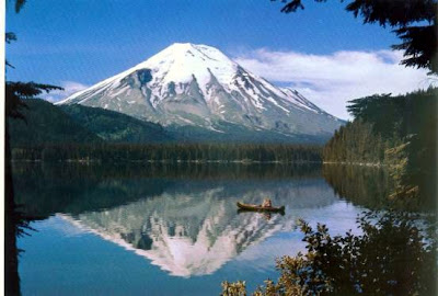
I have always been fascinated with Mt. St. Helens, ever since I felt that small earthquake while going to bed one night several years ago and finding out it wasn't the cat shaking the bed as usual. Realizing the logical alternative to our cat, I jumped from my bed, ran to my parents scared that the monster was preparing to emerge and devour me. I was relieved when I learned it was just an earthquake on Mt. St. Helens...not realizing that a monster, bigger than imaginable, actually was emerging from the depths of the earth.
As time went on, the crater in Mt. St. Helens widened and steam vented from its throat. I would go down to the end of my Vancouver, Washington street, to the intersection where we could see an unobstructed view of the steaming mountain. We watched the white puffs get bigger as it yawned wider and wider from a 180 year nap.
Following much anticipation the monster emerged suddenly on the morning of May 18th, 1980. A 5.1 earthquake from a mile beneath the mountain caused the whole north side of the mountain to slide down at 50-150 miles per hour. As the side of the mountain thinned, the pressurized gasses within the volcano burst through the top and side of the mountain speeding past the land slide at speeds up to 670 miles per hour. The top 1314 feet, propelled by gases up to 1300 degrees, instantly ripped through 230 square miles of lush forests, beautiful lakes and crystal clear rivers; the mountain buried the North Fork Toutle River up to 600 feet in spots...with an average of 150 feet.
In an attempt to escape the angry beast emerging from the volcano, a glacier on the east side of the mountain, liquefied in the heat and raced down the mountain, peaking at 50 miles per hour destroying trees, bridges, homes, roads and other things in its path. Today at the Lahar viewpoint you can see the flood marks on the few trees still standing, burried in the mud flow.
The ashy, hot, gaseous beast burst out of its earthen prison stretching 80,000 feet into the air in 15 minutes. It's cloud and ash-fall, turned day to night in some places downwind to the east. For nine hours ash and gasses poured from the the volcano. In three day's it stretched across the United States--in 15 days it circled the world.
In spite of its fury, only 57 people died in the eruption. It still amazes me that the mountain blew away from the major population areas of Vancouver/Portland and the I-5 corridor. 27 bridges, 200 homes, 185 miles of roadways, 15 miles of Railroad, 40 billion board-feet of lumber was destroyed. Mt. St. Helens National Volcanic Monument.
This is the volcano we visited as a family, almost 30 years later. Today it quietly, yet without rest, tries to rebuild itself by pumping a dump truck's worth of lava to the surface each day. Periodically it coughs gas and ash like a respectful memory of that eventful spring day.
I am still fascinated by the mountain. Evidence of its power can be seen in every stream and river connected to it... and in the landscape that dwarfs its human witness. Below are some of the views we saw on our vacation to the blast-side (north) of Mt. St. Helens.
As you drive up to the mountain on hwy 504 in Washington state, you notice the rivers flowing over grey rocks and 'sand.' The water is clear, but has a green-brown tint to it as it carries its memory of the eruption down stream in a vain hope of being free from its scars.
The road climbs higher and higher through the river valley with incredible vistas. The hilly landscape is covered in green trees and a snake-like line of grey winds through the middle of the valley to indicate the river's path. Beneath the trees are a multitude of grey, brown and rust colored rocks with surprisingly little underbrush. Every once in a while you turn a corner and see the shell of the volcano growing bigger with each glimpse.
Finally we see a sign guarding the entrance to the blast zone. The trees here, if any, are very young with dead, grey tree trunks laying on the ground between the newborns. The mountain jumps out around a big cliff corner and its sickly grey-brown drape-like sides hide the attempts of nature to re-vegetate the area.
Think of this picture on an i-max screen--this picture alone comes nowhere near the full magnitude of the view. You can see one of the lakes created when the mountain dammed up a river. You can also see the grey snake-like river creeping from the mountain. You can see where the mountain 'drained' down the north side (the grey-brown sections lacking vegetation.)
We drove through the blast zone to the Johnston Ridge Observatory which is about halfway up the 8,363 foot mountain as far as elevation goes. And only about 2,000 feet below the crater floor. The view of the mountain, straight into the crater covered the whole scene including your peripheral vision. It was a massive backdrop--you can sort of tell from the size of the people compared to the mountain in this picture.
Notice the steam/gases coming out of the crater dome. This is where the lava is rebuilding its peak to match the other beautiful, yet dangerous mountains scattered all over the Cascade Range.
While we were at the observatory, you could see the trees that were flattened in the blast. You could see how some of the trees were somewhat protected from the powerful wave of rock and hot gasses as it rolled over the areas protected by the hills.
Imagine these hills covered in lush, large evergreen trees. Notice how the trees are all combed in one direction. To the left of the center hill, you can see trees still standing because of the protection of the hill. Mt. St. Helens looms on the right-hand side of the photographer. The green coloring comes from vegetation starting to grow (look at the bottom right corner) but after almost 30 years, there are still very tiny or no trees. We did see several chipmunks and wild flowers. Nature is slowly making a comeback.
Mt. St. Helens is just awe-inspiring: the power and magnificence... andwitnessing how nature recovers from the consequences. Personally, it helps me have great respect and reverence to God and the worlds and life He created...and gives me gratitude to Heavenly Father that He would direct something so powerful away from the most populous nearby areas to protect as many of His children as possible. Just silently awe-inspiring!
Since my vacation, I've been out of step on my blogging. Mainly its been a battle between whether its worth the effort and time compared to other things that need to get done. It seems like you finish one project in time for the next one to come in full swing.
Anyway, I will try to get back on pace so there is something worth visiting for (although I still like going back and listening to my favorite inspirational songs...and when I need a smile, I watch mt son trying to cooperate with a non-cooperative drinking fountain.)
 This is a scene on the sea side of the 'Fort to Sea Trail' where you can retrace the probable path that Lewis and Clark took to go from Ft. Clatsop (Astoria, OR) to Sunset Beach. Trees do a great job of showing depth.
 Here I attempted a 3-D person picture. Usually its nearly impossible to get kids to hold the same position and pose for two pictures from different angles. Fortunately we had a second camera. My wife took a picture with one camera and I took a picture with another camera. Unfortunately, the camera's were spaced too far apart, so although this looks very much 3-D, its not realistic 3-D.